Click to view our Accessibility Statement or contact us with accessibility-related questions


Showing 1 of 2 conversations about:

Cloaca
1906
Oct 30, 2017
bookmark_border

idoc72
1181
Oct 30, 2017
bookmark_border
CloacaThat Casio is an awesome backcountry tool - kind of like you mentioned, 95% of my navigation is with a good topo map and the altimeter. I tried a Suunto, but it ate through batteries fast (the Casio is a "Tough Solar" so I don't have to worry about it crapping out at a critical time), and the Casio's altimeter was more accurate anyways. No photoshopping other than color adjustment and cropping on the phone - otherwise I'd have made it a much bigger fish!
Related Posts
TwentySixAnd
Wrist Check
I thought I would join in on the final posts with my first post of my 'new' watch. I bought my OP one year ago, almost to the day. It's the watch I wear the most (it has a few more love scratches...
Mar 22, 2021

Truelove1
Wrist Check
Soooo..... As I sign off one last time, I thought it fitting to post one of my all time favorites. I’ve had an absolute blast with all of my watch family(you know who you are). I wish each and...
Mar 22, 2021

WathingTime
Wrist Check
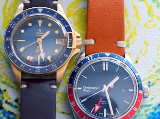
My last post for Watch community and the last question to consider. Bronze or steel, blue or black, England or France. Yema Superman GMT Bronze or Christopher Ward Trident GMT. Something to ponder...
Mar 21, 2021
Trending Posts in More Community Picks

Graham88
Completely surprised by the lack of blade diversity here on Drop...
I’ve been a collector of Blades since before my teens, and a retailer coming up on 15… or maybe 20 years. Drop has really been kind of an interesting experience for me, because I do occasionally get to see some unusual tech and sometimes EDC items that otherwise I might not have been aware of. And maybe it’s because I have a deep love of cutlery and bladed weapons, but I find myself trolling through the site looking at it what’s available; and it’s just it’s pretty much the same. And the bladed community here is just always confused me.. every single knife is about the same, they’re almost all drop points and although the handle materials change and brands change.. it’s really just the same knife over and over and over again... occasionally you’ll see a tanto or a slight variant; but rarely… and almost never a serrated blade. And I’m just deeply amazed at this diversion of serrated blades. And I’m just surprised there isn’t more of a request for diversity here.... and I...
Mar 12, 2020
JellyDPhoto
Can we get Sony E-Mount or other mirrorless camera options please..
Would be nice to see some Sony E mount full frame cameras on here. I currently shoot with a A99 and they killed the lense path for better or more option lenses and now is all E-Mount. 🤔
Jan 13, 2020
RayF
There Are Pandas, and Then There Are Pandas.
And this isn't either of them! The Pandas we're talking about here, are watches, not bears. And what got me thinking about them (again) was a link posted this morning by @cm.rook who pointed a few of us to the very attractive (and not terribly priced) Yema "Rallygraph" Panda which, in it's most traditional arrangement, looks like the one on the left, but can also be had in the version on the right: The model on the left is a true Panda, while the model on the right is called a reverse Panda. The reason for that distinction is clear--Panda bears, only come in the first arrangement. Now at this point, everyone should be thinking about the most well-know Panda, The Rolex Panda, which is actually a Daytona, and among Rolex Daytonas, the most famous of which is the Paul Newman Daytona, which was famous first, because it was Paul's, and second because it sold at auction for $17.8 million (US Dollars). The story of that auction is well-known so I'll only...
Nov 8, 2019



By the way, is the photo Photoshopped? :-)