Click to view our Accessibility Statement or contact us with accessibility-related questions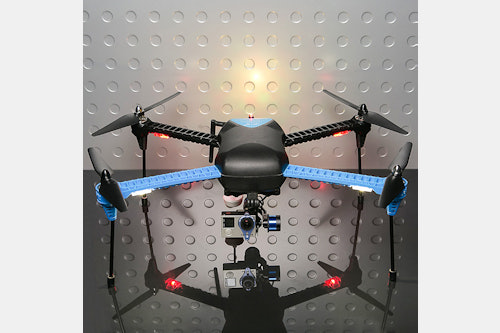
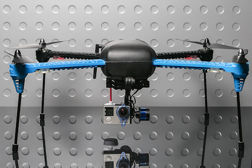


3DR Iris+ Aerial Surveyor Drone
01 / 07
3DR Iris+ Aerial Surveyor Drone
bookmark_border
Where's the price?
To negotiate the best possible price for our customers, we agree to hide prices prior to logging in.
49 requests
Product Description
The 3DR Iris+ Aerial Surveyor Drone is designed to shoot photos and video from stunning new perspectives. With world-renowned autopilot technology, you have the power to command the drone to fly anywhere you want for incredible footage Read More
Specs
- 3D Robotics
- Operating frequency: 915 mHz
- Flight time: Up to 22 minutes
- Payload capacity: 14 oz (400 g)
- Autopilot: Pixhawk v2.4.5
- Firmware: ArduCopter 3.2
- GPS: 3DR uBlox GPS with compass
- Telemetry radio: 3DR radio telemetry v2 (915 mHz or 433 mHz)
- Motors: 920 kV
- Battery: 3S 5.1 Ah 8C lithium polymer (only compatible with 3S lithium polymer batteries)
- Low battery voltage:10.5 V
- Maximum voltage: 12.6 V
- Radio range: Up to 0.6 miles (1km)
- Integrated LEDs on all arms for directional awareness
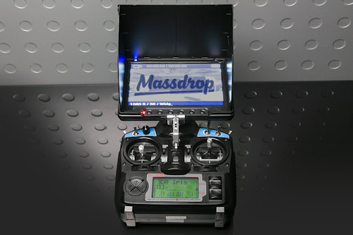
- Remote control with on-screen telemetry for instant data as you fly
- Self tightening screw-on propellers
- Automatic mission planning from Android device let’s you draw flight plans
- Follow me mode
- Loiter mode
- 360-degree view
- Dimensions: 18 x 11 x 8.5 in (46 x 28 x 22 cm)
- Weight: 3.6 lb (1.6 kg)
- Camera compatibility: GoPro HD Hero
Included
- Ready-to-fly IRIS+ quadcopter
- Propellers
- Battery
- Charger
- Controller and ground station radio
- Set of four tall legs
- Tool kit
- Android OTG and micro USB cables
- Operation Manual and Flight Checklist
Shipping
Estimated ship date is Nov 12, 2015 PT.
Payment will be collected at checkout. After this product run ends, orders will be submitted to the vendor up front, making all orders final.
Recent Activity


Related Products


Drop Refurbished
Like-new products you can trustDrop Rewards
Get $5 for every 500 points you earn! Learn more
Drop Keyboard Club
Become a member and expand your keycap collectionCollaborate With Us
For Brands & DesignersFollow Drop